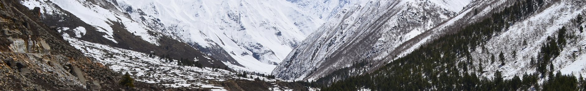
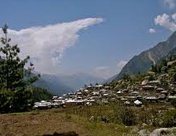
A region of rugged beauty, Kinnaur is a wonderland where rivers flow through the plunging Himalayan gorges. The crisscrossed roads of the old Hindustan–Tibet highway will take tourists to this hidden village called Kinnaur. It is a tiny hamlet in India where beauty resides and that is why it is acknowledged as the "Land of fairy tales." Sharing its eastern border with Tibet, Kinnaur has noticeable resemblance with Tibetan culture. The hilltop is guarded by three famous hill ranges- Zanskar, Himalaya and Dhauldhar. The terrains of Kinnaur create a spell which encourages all the adventurers to dive into this magic.
To one's astonishment, there is only one road which connects Kinnaur with the rest of the India, although the road remains closed for half of the year. This highway along the bank of river Satluj offers stunning views and sightseeing options to keep tourists engaged and enthralled throughout the journey.
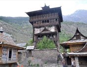
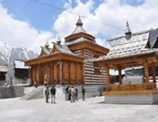
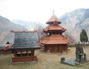
Legends say that the kingdom of Kinnaur was under the control of multiple invaders and crusaders namely Magadh, Maurya, Kirata, Kamboja, Panasika, and Valhika. Even for a short period during the 9th and 12th centuries, the Guge kingdom of Tibet also regulated the citizens of Kinnaur. Political turmoil's and rivalry amongst the natives lead to imbalance in the territory. The situation remains same until Mughal Emperor Akbar conquered the area. Kinnaur valley was known as 'Chini Tehsil' then. There's everything worth cherishing in Kinnaur: mighty mountains, orchid farmlands, apple farms, valleys, and vineyards. The district is divided into three administrative areas-Pooh, Kalpa, and Nichar. The two main valleys which are worth a visit in Kinnaur are Sanga Valley (also known as Baspa Valley) and Hangrang valley. The sanga valley is decorated with alpine meadows, snowy summits, orchid farms and features the traditional Kinnauri wood-and-stone-style temples and houses. Hangrand valley is regarded by the adventurers as their favourite stopover for thrilling activities like paragliding, angling and rafting.
The roads of Kinnaur are just not meant for the faint-hearted people. To savor the sensational vistas of Kinnaur one will have to cross some of the deadliest pathways. The pristine peaks of Kinnaur keep on calling people from all across India to behold its heart throbbing beauty which can be a prelude to love, at first sight.
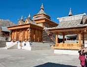
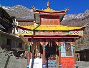
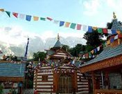
Journey to Kinnaur via roadways can be really a mesmerizing affair worth remembering as there are multiple places which have conquered the imagination of known writers and poets. Sarahan is a small village which tourists can visit on their way to Kinnaur. The small hamlet is the earthly abode of the goddess Bhimakali temple. The temple is made of timber and stones and houses the revered shrine of goddess Bhimakali (the local version of Kali) beneath a beautiful silver filigree canopy. Morang, a small village located on the left bank of river Satluj is yet another magnetic charm.
One of the best ways to discover Kinnaur is to walk on the hilly terrains, sleep under the stars, admire the natural beauty and exchange smiles with locals in far-off villages. Parikrama (circumambulation) of Kinnaur Kailash is among the popular trekking trails. Bhaba Valley and Sangla Valley treks are other popular trails. As per legends, Kinnaur Kailash is the abode of Lord Shiva. Other places worth visiting in Kinnaur are Nako Lake and Lipa-Asrang Sanctuary.
From the grand city event to the small gatherings, people of Kinnaur know how to celebrate every festival. Sajo Festival, Pagul Festival, Dakhraini Festival, Flaich Ukhyang Festival and Losar Festival are some of the fairs which showcase the culture of Kinnaur. The red and golden apples of Kinnaur are worth relishing. The annual apple harvest lures hundreds of fruit wholesalers from across India.
The best part of Kinnaur is the plethora of options available here for experiencing thrill cuddled in the mighty Himalayas. For those who want to keep away from the cacophony and concerns of daily life then Kinnaur is the place to be. This captivating beauty of Kinnaur is simply photogenic and blissful.
Adventure activities
- High terrains' of Kinnaur facilitates multiple adventure activities. In Sangle Valley, tourist can enjoy adventurous Activities like Rock Climbing, Rappelling, Nature Trails, bird watching and River Crossing.
- Parikarma of Kinnaur Kailash' is the famous trekking route of Kinnaur. Bhaba Valley and Sangla Valley treks are other popular trails.
Where to stay
There are different categories of hotels in Kinnaur to cater to the needs of customers. The Monk-Kalpa (Below Roghi Road), Hotel Kinner Kailash, (Kalpa), Panchali, Hotel apple pie (Kalpa), Hotel Apple Pie (Sangla Valley) are some of the best places to stay on a tour to Kinnaur.
Where to eat
Little Chef Hotel & Restaurant (Reckong Peo), Hotel Srikhand, Cafe 42 (Sangla) are some of the best places to enjoy scrumptious Indian and International cuisines. Do try the salted tea called 'Cha' which is a favourite among the people of Kinnaur. Sattu, made of parched barley flour, is another favourite dish here.
Weather and Climate
Winters (October to March): (-4)-22°C
Summers (April to September): 0°C-26°C
Best time to Visit: May to October
How to Reach
By Airways: There is no direct flight for Kinnaur, though Jubbarhatti airport is the nearest Airport which can be reached from Delhi.
By Railways: There is no railway connectivity as well. The nearest railway station is in Shimla which is located at a distance of 235 km from Kinnaur. There are many state owned buses and cars that are available from Shimla to Kinnaur.
By Roadways: NH-22 is the best way to reach Kinnaur. Jeeps and Taxis can be used to reach Kinnaur though there are some fixed schedules. Even Himachal Pradesh Transport Corporation runs a number of buses to different parts of Kinnaur. Kinnaur is located at a distance of 235 km from Shimla and 350 km from Chandigarh. One should avoid the Lahaul and Spiti route to reach Kinnaur as it is more prone to landslides.


 Plan Trip
 Call Us
 Packages
 Home
Home